

Munich Center for Machine Learning
Geospatial Machine Learning Libraries
Abstract
Recent advances in machine learning have been supported by the emergence of domain-specific software libraries, enabling streamlined workflows and increased reproducibility. For geospatial machine learning (GeoML), the availability of Earth observation data has outpaced the development of domain libraries to handle its unique challenges, such as varying spatial resolutions, spectral properties, temporal cadence, data coverage, coordinate systems, and file formats. This chapter presents a comprehensive overview of GeoML libraries, analyzing their evolution, core functionalities, and the current ecosystem. It also introduces popular GeoML libraries such as TorchGeo, eo-learn, and Raster Vision, detailing their architecture, supported data types, and integration with ML frameworks. Additionally, it discusses common methodologies for data preprocessing, spatial–temporal joins, benchmarking, and the use of pretrained models. Through a case study in crop type mapping, it demonstrates practical applications of these tools. Best practices in software design, licensing, and testing are highlighted, along with open challenges and future directions, particularly the rise of foundation models and the need for governance in open-source geospatial software. Our aim is to guide practitioners, developers, and researchers in navigating and contributing to the rapidly evolving GeoML landscape.
keywords
Geospatial, Machine Learning, Software Libraries, Open Source1 Introduction
Machine learning (ML) software libraries have played a foundational role in both shaping ML research and the commoditization of ML models. Libraries such as scikit-learn (Pedregosa et al., 2011), TensorFlow (Abadi et al., 2016), and PyTorch (Paszke et al., 2019) incorporate best practices, provide composable APIs, and abstract low-level engineering complexity, allowing researchers and practitioners to focus on experimentation, implementation of higher-level features, and conceptual development. A well designed software library provides a platform that users can build upon to pursue their agendas. As a result, the accessibility and maturity of ML tooling are tightly coupled with research progress.
Beyond general-purpose frameworks, domain-specific libraries further lower the barriers to research in particular subfields. These libraries often provide data loaders, evaluation metrics, pretrained models, and architecture templates specific to that domain. For example, the torchvision library (Marcel & Rodriguez, 2010) simplifies experimentation in computer vision by including standard datasets (e.g., CIFAR (Krizhevsky & Hinton, 2009), ImageNet (Deng et al., 2009)), data augmentation routines, and reference implementations of neural network architectures. In natural language processing (NLP), the Hugging Face ecosystem has standardized tokenization, model configuration, and inference across transformer-based architectures (Wolf et al., 2019), enabling large-scale evaluation and pretraining. Similar domain-specific tooling ecosystems exist in reinforcement learning (e.g., OpenAI Gym (Brockman et al., 2016)), speech (e.g., torchaudio (Yang et al., 2022)), and time series (e.g., GluonTS (Alexandrov et al., 2020)), all of which have substantially influenced research agendas and benchmarks.
In contrast, the development of libraries tailored to geospatial machine learning (GeoML) has lagged behind. This gap is notable given the increasing volume and accessibility of satellite and aerial imagery from public and commercial platforms. Remotely-sensed data support a wide range of applications — including land cover mapping (Karra et al., 2021), agricultural monitoring (Mulla, 2013), disaster response (Van, 2013), and climate modeling (Rolnick et al., 2022) — but present a set of challenges not typically encountered in standard ML workflows. As presented in the introduction chapter of this book, Earth observation images vary in spatial resolution (from millimeters to tens of kilometers per pixel), spectral characteristics (e.g., 3-band RGB imagery vs. 13-band multispectral Sentinel-2 imagery vs. 242-band Hyperion imagery), and temporal cadence (every five minutes from the NASA GOES satellites, to on-demand tasking for commercial high-resolution satellites, to every 16 days for Landsat 9). Further complications include non-uniform data coverage over the Earth, cloud occlusion, differing coordinate reference systems (CRS), and file formats optimized for spatial indexing rather than machine learning (Rolf et al., 2024). These characteristics require preprocessing steps such as reprojection, resampling, and cloud masking, none of which are directly supported by conventional ML data pipelines. As a result, integrating geospatial data into an ML workflow typically requires manual interfacing with specialized libraries such as GDAL (GDAL/OGR contributors, 2022), creating substantial friction between data access and model development.
Despite these challenges, recent years have seen progress toward standardizing workflows for GeoML through the development of libraries explicitly designed for geospatial data in machine learning contexts. TorchGeo (Stewart et al., 2024), for example, builds on PyTorch to provide dataset abstractions, spatial sampling utilities, and support for georeferenced imagery and vector data. Other libraries, such as eo-learn (Aleksandrov, 2018) and Raster Vision (Azavea/Element 84 & Cheetham, 2017), offer higher-level frameworks for remote sensing tasks, including land cover classification, semantic segmentation, and change detection. These libraries attempt to bridge the gap between geospatial data infrastructure and modern ML tooling, offering primitives for common operations such as patch extraction, label alignment, and tiling. However, the ecosystem remains fragmented, with limited support for tasks such as temporal modeling, sensor fusion, or distributed inference over petabyte-scale datasets. Moreover, unlike domains such as vision and language modeling, GeoML currently lacks a unifying toolkit that combines data curation, model training, and deployment into an integrated framework, though considerable progress has been made in recent years. While the current chapter primarily focuses on Python libraries as much of the active development, GeoML developments in other languages such as R have similar or related issues.
2 Methodology
By definition, GeoML libraries must support two core tasks: processing geospatial data, and integrating it into machine learning workflows. Their functionality spans input/output (I/O) operations, internal data representations, and dataset handling.
Most GeoML libraries rely on the Geospatial Data Abstraction Library (GDAL) either directly or indirectly to support I/O operations. GDAL provides a consistent API for interacting with a wide range of raster and vector data formats — as of September 2025, it includes 155 raster drivers and 83 vector drivers, covering formats such as GeoTIFF, Zarr, HDF5, NetCDF, Esri Shapefile, and GeoPackage. In Python, libraries like rasterio (Gillies, 2013) and fiona (Gillies et al., 2024) wrap GDAL’s API and provide an additional layer of abstraction and additional features (e.g., vectorization, rasterization, and fine-grained management of environment variables to control GDAL behavior). In R, terra (Hijmans et al., 2018) and sf (Pebesma, 2018) provide similar support for raster and vector operations at a higher level of abstraction. Even higher-levels of abstraction exist through libraries such as xarray (Hoyer & Joseph, 2017), rioxarray (Snow, 2019), and geopandas (Jordahl, 2013), which provide array- or dataframe-based abstractions that retain coordinate reference system (CRS) metadata and spatial transforms. Some geospatial file formats can also be accessed through alternative backends. h5py (Collette, 2008), zarr (Miles, 2015), and tifffile (Gohlke, 2018) all provide direct interfaces for HDF5, Zarr, and TIFF files, respectively. Similarly, GeoJSON files can be read using any standard JSON parsers, although geospatial-aware libraries (like fiona) ensure proper CRS interpretation and coordinate handling. A key feature throughout all GeoML libraries is how they ensure that the geospatial metadata of inputs are taken into account — any corresponding outputs will need this information in order to be georeferenced for downstream analysis. Machine learning libraries that do not support this require users to (a) have knowledge of how geospatial metadata works and (b) develop ad-hoc methods for propagating geospatial metadata, both of which can easily allow for bugs to be introduced.
Another key feature of GeoML libraries is how spatial and temporal data are represented within the library. Spatial and temporal joins, in particular, are common operations for setting up GeoML experiments. For example, training a model to predict whether land is cropland or not from a time series of satellite imagery observations over the planting season of that area requires several key steps. First, representing a time series of multispectral satellite imagery over the same location requires a temporal join with corresponding decisions. Does the library itself allow for the temporal join to be performed? How will missing observations be handled and how will the time dimension be represented (densely in 4D, sparsely with pointers to 3D tensors)? How are layers with differing coordinate reference systems and spatial resolutions handled? Second, a spatial join between the resulting imagery stack and a known cropland mask is necessary in order to create labeled examples that can be fed into a machine learning pipeline. If there are many different cropland masks, or satellite imagery layers, then a spatial index will be needed to ensure that intersections between the layers can be computed quickly. Further, the spatial join must also take different coordinate reference systems and/or spatial resolutions into account — some layers will likely need to be reprojected and resampled in an appropriate manner before further analysis can be done. The cropland masks could also be in a vector format and need to be rasterized or otherwise transformed into a format that can be used directly in modeling.
GeoML libraries also differ in how they support benchmark datasets. The GeoML community has proposed a growing set of benchmark datasets intended to facilitate algorithmic comparison and standardized evaluation on a wide variety of tasks. These datasets typically pair remotely-sensed imagery with structured labels, such as land cover classifications (Robinson et al., 2019), object boundaries (Kerner et al., 2025), or change detection masks (Chen & Shi, 2020). Unlike domains such as computer vision or NLP, geospatial benchmark datasets often lack standardized data loaders or preprocessing routines. As a result, researchers are frequently required to write custom scripts for parsing, tiling, and aligning data. This introduces inconsistencies and hinders reproducibility. GeoML libraries can substantially reduce this friction by implementing standardized, reusable data loaders for popular benchmarks. Features that distinguish high-quality dataset support include:
- •
adherence to published train/validation/test splits;
- •
support for user-defined or random splits, including spatial stratification;
- •
compatibility with PyTorch or TensorFlow Dataset abstractions, enabling seamless integration into training pipelines;
- •
additional utilities such as on-the-fly reprojection, resampling, normalization, augmentation, or class remapping; and
- •
built-in visualization tools for inspecting inputs, labels, and predictions.
Taken together, these capabilities define the core functionality and value of a GeoML library. By abstracting the geospatial data pipeline from raw file access and metadata handling to dataset construction and integration with ML training loops, these libraries allow researchers and practitioners to focus on model development rather than infrastructure. However, the design choices made at each stage, such as metadata preservation, spatial joining logic, temporal indexing strategies, and dataset standardization, directly affect model reproducibility, comparability, and deployment. In the remainder of the chapter we highlight the history of GeoML libraries, break down existing “state-of-the-art” libraries along the dimensions we describe here, expand on our example of cropland mapping, and finally discuss best practices for GeoML library development from a software engineering standpoint.
3 State of the Art and Current Developments
Before jumping in to the current state of GeoML library development, it helps to first understand how we got there.
3.1 A Brief History
The development of GeoML software libraries has evolved alongside the rise of machine learning in computer vision. Beginning in the early-2000s, researchers began repurposing general-purpose machine learning frameworks to work with the unique formats and challenges of satellite and aerial imagery. Over time, this ad hoc adaptation gave way to a more intentional, ecosystem-wide effort to build specialized tools for Earth observation data.
One of the earliest known GeoML libraries, SPy (Spectral Python), began development in 2001 with simple iterative clustering methods for hyperspectral imagery, later adding -means clustering and perceptron classifiers (Boggs, 2001). The library predates most modern ML frameworks, and all methods are implemented from scratch in NumPy (Harris et al., 2020). SPy has successfully survived several transitions (Python 2 3, CVS SVN Git) and is still maintained to this day. OTB (Orfeo ToolBox) is another popular software library for processing optical, multispectral, and radar imagery (Grizonnet et al., 2017). Initial development began in 2006 by the French national space agency (CNES) as part of the Orfeo Program, targeting high resolution imagery from the Orfeo constellation (Pléiades and COSMO-Skymed). OTB offered early support for support vector machines (SVMs) via LibSVM (Chang & Lin, 2011) and later added support for gradient boosted decision trees, -nearest neighbors (-NNs), and multilayer perceptrons (MLPs) from OpenCV (Bradski & Kaehler, 2000) and -means and random forests from the Shark machine learning library (Krause, 2009). OTB itself is written in C++, with a command-line interface, Python bindings, and an official QGIS plugin.
The earliest known geospatial deep learning libraries began development in 2016. TrailBehind introduced DeepOSM (Johnson, 2016), which built on top of the now-defunct TFLearn (Damien, 2016) and supported automatic downloading and preprocessing of labeled imagery for road network detection using OpenStreetMap (OSM) (OpenStreetMap contributors, 2017). Hyperspectral was developed by researchers at IIT Kharagpur, with early TensorFlow-based experiments with MLPs and CNNs on hyperspectral imagery (Santara et al., 2016). Later that year, ONERA and IRISA released DeepNetsForEO (Audebert et al., 2017), initially built on Caffe (Jia et al., 2014) and later ported to PyTorch. Notably, it was the first library to offer pretrained models on multispectral remote sensing imagery. All three libraries were discontinued within a few years of release. They were never packaged for PyPI or other standard software registries, and instead required knowledge of Git and Docker for installation. Nonetheless, they established foundational ideas — especially the importance of pipelines for data handling — that would influence the next generation of GeoML libraries.
In 2017, the first broadly adopted, formally maintained geospatial deep learning libraries were introduced. In the R ecosystem, SITS (Satellite Image Time Series) was launched (Simoes et al., 2021). SITS is a library developed by e-sensing with a focus on time series analysis and data cube construction from providers such as AWS, the Microsoft Planetary Computer, and Copernicus Data Space. Built on R bindings to libtorch, SITS emphasizes accessibility, with formal documentation, CRAN (and more recently PyPI) packaging, and a free online book (Camara et al., 2024). One day after the initial commit of SITS, in the Python ecosystem, Azavea started work on Raster Vision (Azavea/Element 84 & Cheetham, 2017). Raster Vision is a modular framework for training and deploying deep learning models on arbitrary raster datasets. Initially built on TensorFlow, it migrated to PyTorch in 2019. The authors of DeepNetsForEO returned with DeepHyperX, a library for hyperspectral classification using scikit-learn and PyTorch (Audebert et al., 2019). However, its development fractured across multiple forks on GitLab and GitHub and was later abandoned.
Four influential libraries followed in 2018. Pyinterpolate was introduced by Dataverse Labs, with support for several geostatistical interpolation techniques and learning-based Kriging methods (Moliński, 2022). OTBTF was created as a TensorFlow and Keras plugin for Orfeo ToolBox and provides both Python and C++ APIs, but is only distributed through Docker due to its compilation requirements (Cresson, 2018). Sentinel Hub released eo-learn, a scikit-learn-compatible pipeline that offers strong integration with Sentinel Hub products and showed the possibility of cloud native workflows (Aleksandrov, 2018). Mapbox released RoboSat, built on PyTorch and torchvision, which offered a command-line interface for data preparation, training, and postprocessing (Hofmann & Kowshik, 2018). RoboSat was eventually discontinued and briefly revived as RoboSat.pink, then Neat-EO.pink, before being abandoned again in 2020.
In 2019, the ecosystem diversified with several new projects. The Python Spatial Analysis Library (PySAL) introduced spopt, providing several spatial optimization techniques including clustering methods from scikit-learn (Feng et al., 2022). NASA released DELTA, a TensorFlow-based toolkit for large-image tiling and semantic segmentation (Coltin, 2019). The TorchSat project attempted to adapt torchvision to the geospatial domain (Wang, 2019). CosmiQ Works launched Solaris, a PyTorch framework for object detection (Weir, 2019). Finally, Microsoft’s AI for Earth team created AIDE (Kellenberger et al., 2020), a modular web-based annotation interface with Detectron2 (Wu et al., 2019) integration. While each offered novel features, none of these libraries besides spopt were maintained beyond 2022.
The COVID-19 pandemic brought a slowdown in 2020. Only one major library, AiTLAS, was released that year (Dimitrovski et al., 2023a). Developed by Bias Variance Labs, it built on PyTorch, scikit-learn, and eo-learn to support common tasks like classification and semantic segmentation using curated datasets. It also attempted the first large-scale benchmarking of more than 500 deep learning models on 22 EO classification datasets with its AiTLAS Benchmark Arena (Dimitrovski et al., 2023).
In 2021, GeoML software development entered a new phase of stability and community-driven growth. The Weecology group at the University of Florida released DeepForest, targeting object detection of tree crowns in RGB drone imagery with pretrained torchvision models (Weinstein et al., 2020). Trillium Technologies launched ML4Floods, an end-to-end PyTorch pipeline for flood extent estimation (Mateo-Garcia et al., 2021). Microsoft’s AI for Good Lab and the University of Illinois Urbana-Champaign introduced TorchGeo, a PyTorch-native library combining the reproducibility of torchvision-style datasets with raster/vector data handling capabilities similar to Raster Vision (Stewart et al., 2024). A similar project, torchrs was launched in parallel and was subsequently merged into TorchGeo (Corley, 2021). Other major 2021 releases included ServiceNow’s GEO-Bench, a foundation model benchmarking suite with 20 built-in datasets (many curated using TorchGeo) (Lacoste et al., 2023), and IGNF’s Myria3D, uniquely focused on aerial LiDAR segmentation (Gaydon, 2022).
By contrast, most libraries launched in 2022 were eventually abandoned. Baidu’s PaddleRS (PaddlePaddle Authors, 2022) built on the PaddlePaddle deep learning framework (Ma et al., 2019), making it the first Chinese-developed GeoML library to gain traction. Wherobots released GeoTorch, later renamed GeoTorchAI (Chowdhury & Sarwat, 2022), offering scalable spatial indexing with Apache Sedona (Yu, 2015), but the project was discontinued in favor of TorchGeo. Raster4ML, designed for agricultural research, provided over 350 spectral indices and scikit-learn compatibility (Bhadra, 2023). Finally, Kraina AI released srai (Spatial Representations for Artificial Intelligence), a library providing pre-computed embeddings and spatial data visualization and processing tools (Gramacki et al., 2023). Among these libraries, only srai is still maintained to this day.
A new wave of tools emerged in 2023. Moonshine focused on hosting pretrained semantic segmentation models but was abandoned (Harada, 2023). Open Geospatial Solutions launched both samgeo (Wu & Osco, 2023), a GUI wrapper for Meta’s Segment Anything Model (SAM) (Kirillov et al., 2023), and GeoAI (Wu, 2023), a general-purpose toolkit for satellite, LiDAR, and vector data built atop TorchGeo and scikit-learn. Geodl, another R library built on top of the torch and terra packages, brought 2D convolutional neural networks to the R GeoML ecosystem for the first time (Maxwell et al., 2024). Scikit-eo also debuted, offering another scikit-learn interface for EO tasks (Tarazona et al., 2024).
In 2024, IBM released TerraTorch, a toolkit for fine-tuning foundation models, built on TorchGeo (Gomes et al., 2025). Together with GEO-Bench and GeoAI, TerraTorch represents a second generation of GeoML libraries —– those that complement instead of compete with core infrastructure by extending existing GeoML libraries like TorchGeo.
Launched in 2025, UAV4GEO’s GeoDeep is focused on providing a lightweight solution for object detection and semantic segmentation, with dependencies only on onnxruntime and rasterio (Toffanin, 2025). This library was inspired by and uses some code from Deepness (Aszkowski et al., 2023) and DeepForest. Cambridge’s GeoTessera is the first library to focus solely on embeddings, providing easy access to learned representations from the Tessera foundation model (Feng et al., 2025).
The evolution of GeoML software has mirrored broader trends in machine learning and open-source development. While many early projects were short-lived, they introduced core abstractions — data tiling, preprocessing pipelines, pretrained weights — that persist in modern libraries. In recent years, the field has converged around modular, PyTorch-based tooling with strong community support, clearer maintenance practices, and increasing interoperability.
3.2 Current Landscape
| Feature Count | Feature Support | |||||||
|---|---|---|---|---|---|---|---|---|
| Library | ML Backend | Datasets | Weights | CLI | GUI | Reprojection | STAC | Time Series |
| TorchGeo | PyTorch | 127 | 120 | yes | no | yes | no | partial |
| OTB | LibSVM, OpenCV, Shark | 0 | 0 | yes | yes | yes | no | no |
| TerraTorch | PyTorch | 27 | 13 | yes | no | yes | no | partial |
| DeepForest | PyTorch, TensorFlow* | 0 | 4 | no | no | no | no | no |
| Raster Vision | PyTorch, TensorFlow* | 0 | 6 | yes | no | yes | yes | partial |
| samgeo | PyTorch | 0 | 0 | no | yes | yes | no | no |
| spopt | scikit-learn | 0 | 0 | no | no | yes | no | no |
| SITS | R Torch | 22 | 0 | no | no | yes | yes | yes |
| SPy | numpy | 3 | 0 | no | no | no | no | no |
| srai | PyTorch | 0 | 0 | no | no | no | no | no |
| ML4Floods | PyTorch | 0 | 0 | no | no | yes | no | partial |
| GEO-Bench | PyTorch | 12 | 0 | no | no | no | no | no |
| scikit-eo | scikit-learn, TensorFlow | 0 | 0 | no | no | no | no | partial |
| GeoAI | PyTorch | 0 | 6 | no | no | yes | yes | no |
| Myria3D | PyTorch | 0 | 0 | partial | no | no | no | no |
| GeoTessera | scikit-learn | 0 | 0 | yes | no | yes | no | no |
| OTBTF | TensorFlow | 0 | 0 | yes | no | yes | no | no |
| GeoDeep | ONNX | 0 | 7 | yes | no | yes | no | no |
*Support was dropped in newer releases.
| Library | Contributors | Forks | Watchers | Stars | Issues | PRs | Coverage | License |
|---|---|---|---|---|---|---|---|---|
| TorchGeo | 108 | 473 | 56 | 3,663 | 173 | 2,339 | 100% | MIT |
| OTB | 41 | 121 | 40 | 375 | 3 | 24 | 56% | Apache-2.0 |
| TerraTorch | 40 | 101 | 23 | 601 | 92 | 634 | 55% | Apache-2.0 |
| DeepForest | 35 | 217 | 17 | 657 | 96 | 530 | 86% | MIT |
| Raster Vision | 33 | 393 | 71 | 2,163 | 40 | 1,465 | 90% | Apache-2.0 |
| samgeo | 24 | 351 | 59 | 3,408 | 33 | 154 | 13% | MIT |
| spopt | 23 | 55 | 12 | 341 | 30 | 265 | 77% | BSD-3-Clause |
| SITS | 17 | 86 | 27 | 515 | 26 | 653 | 91% | GPL-2.0 |
| SPy | 15 | 146 | 35 | 636 | 25 | 38 | 69% | MIT |
| srai | 15 | 27 | 12 | 316 | 104 | 280 | 92% | Apache-2.0 |
| ML4Floods | 13 | 42 | 18 | 170 | 1 | 73 | 0% | LGPL-3.0 |
| GEO-Bench | 13 | 12 | 12 | 153 | 8 | 9 | 51% | Apache-2.0 |
| scikit-eo | 8 | 24 | 6 | 206 | 4 | 14 | 32% | Apache-2.0 |
| GeoAI | 7 | 202 | 33 | 1,587 | 24 | 174 | 6% | MIT |
| Myria3D | 7 | 31 | 14 | 259 | 18 | 79 | 57% | BSD-3-Clause |
| GeoTessera | 6 | 14 | 4 | 146 | 11 | 9 | 15% | ISC |
| OTBTF | 5 | 39 | 11 | 166 | 22 | 19 | 55% | Apache-2.0 |
| GeoDeep | 3 | 24 | 9 | 326 | 3 | 3 | 0% | AGPL-3.0 |
| PyPI/CRAN | Conda | Total | |||
| Library | Last Week | Last Month | All Time | All Time | All Time |
| TorchGeo | 69,430 | 200,906 | 845,353 | 40,949 | 886,302 |
| OTB | 0 | 0 | 0 | 0 | 0 |
| TerraTorch | 3,870 | 29,514 | 130,473 | 0 | 130,473 |
| DeepForest | 2,483 | 6,526 | 988,841 | 97,503 | 1,086,344 |
| Raster Vision | 4,666 | 8,613 | 221,409 | 5,872 | 227,281 |
| samgeo | 2,319 | 6,692 | 274,609 | 54,307 | 328,916 |
| spopt | 13,289 | 44,498 | 1,122,138 | 251,912 | 1,374,050 |
| SITS | 477 | 1,967 | 22,502 | 136,850 | 159,352 |
| SPy | 17,720 | 59,792 | 1,445,738 | 150,137 | 1,595,875 |
| srai | 661 | 1,962 | 51,103 | 0 | 51,103 |
| ML4Floods | 90 | 195 | 10,254 | 0 | 10,254 |
| GEO-Bench | 609 | 1,818 | 58,756 | 0 | 58,756 |
| scikit-eo | 515 | 598 | 22,281 | 0 | 22,281 |
| GeoAI | 1,765 | 7,277 | 63,399 | 16,747 | 80,146 |
| Myria3D | 13 | 33 | 4,429 | 0 | 4,429 |
| GeoTessera | 348 | 1,218 | 3,725 | 0 | 3,725 |
| OTBTF | 0 | 0 | 0 | 0 | 0 |
| GeoDeep | 229 | 920 | 18,540 | 0 | 18,540 |
As of September 2025, the current set of popular GeoML libraries under active development include: TorchGeo, OTB, TerraTorch, DeepForest, Raster Vision, samgeo, spopt, SITS, SPy, srai, ML4Floods, GEO-Bench, scikit-eo, GeoAI, Myria3D, GeoTessera, OTBTF, and GeoDeep. Table 1 summarizes the machine learning backend (e.g., PyTorch, TensorFlow, scikit-learn), dataset/model availability, and any notable features such as a command-line interfaces (CLI), graphical user interfaces (GUI), support for automatic reprojection and resampling, SpatioTemporal Asset Catalogs (STAC), or time-series analysis for each of these libraries. Tables 2 and 3 display a number of metrics useful for gauging the popularity and stability of each library.11 1 All tables are maintained in perpetuity at https://torchgeo.rtfd.io/en/latest/user/alternatives.html. If any metrics are out of date, please open a pull request to update them. While the number of GitHub stars and PyPI downloads are useful for gauging popularity, the number of contributors and test coverage are much more reliable for gauging the stability and long-term success of the library. Finally we describe the abstractions in three popular libraries: TorchGeo, eo-learn, and Raster Vision. We also assess the typical user base, limitations, and scope of each library.
3.2.1 TorchGeo
TorchGeo is a PyTorch domain library designed to unite machine learning and remote sensing experts under a single platform. It defines two broad classes of datasets: GeoDataset for uncurated raster and vector data files and NonGeoDataset for curated benchmark datasets.
Like other libraries on this list, users can directly use GeoDataset and its subclasses, RasterDataset and VectorDataset, to load and process arbitrary raster and vector data. Each dataset consists of a geopandas GeoDataFrame index, allowing different datasets to be intelligently composed based on spatiotemporal intersection or union. The resulting dataset can then be queried by a spatiotemporal slice, allowing users to quickly load small patches of imagery and masks from large collections of raster scenes. Reprojection and resampling are automatically handled by rasterio and fiona, and users can specify which spectral bands they want to load. To ease spatiotemporal indexing, TorchGeo defines a GeoSampler interface, allowing users to select various random (for training) or sequential (for inference) sampling strategies.
TorchGeo also includes a number of curated ML-ready benchmark datasets designed to train and evaluate models for specialized tasks such as crop type mapping, biomass estimation, or disaster response. Each of these datasets provides an input image and an output target, such as a semantic segmentation mask or object detection bounding box. In total, TorchGeo provides over 125 built-in geospatial and benchmark datasets, more than all other libraries combined.
Another primary focus of TorchGeo is on providing pretrained foundation models capable of being finetuned for any task. TorchGeo provides over 120 such model weights, including models pretrained on Landsat, NAIP, and Sentinel imagery and newer “sensor-agnostic” foundation models like Scale-MAE (Reed et al., 2023), DOFA (Xiong et al., 2024), CROMA (Fuller et al., 2023), Panopticon (Waldmann et al., 2025), and Copernicus-FM (Wang et al., 2025).
TorchGeo places a great deal of emphasis on documentation and testing, with 100% test coverage on three Python versions, three platforms, and the minimum and maximum supported dependency versions. It also has more than double the number of contributors as any other library on this list, demonstrating its widespread adoption by the community. Its component-based nature, providing PyTorch-compatible datasets and models for the community, naturally allows other libraries like TerraTorch and GeoAI to build on top of TorchGeo, extending its features and capabilities.
3.2.2 eo-learn
eo-learn is a Python library that aims to bridge the gap between the remote sensing and data science ecosystems. It is highly coupled with the commercial Sentinel Hub library and ecosystem, and enables users to build reusable workflows based around the EOPatch, EOTask, and EOWorkflow abstractions. An EOPatch contains all types of data for a given bounding box location — raster data with time series support, vector data, and one-off masks like land cover information. EOTasks operate on EOPatches and transform them, for example performing cloud masking, computing spectral indices, classical feature extraction pipelines, and/or classification. Finally, EOTasks are organized into computational graphs that exchange patch objects and run in EOWorkflows, allowing for parallelization and record keeping.
For data I/O, eo-learn relies on GDAL (typically through rasterio) for reading geospatial raster data, and also uses OpenCV, pandas, SciPy, and Zarr under the hood. This means it can handle common raster formats and even work with large out-of-core datasets (Zarr provides chunked, on-disk array storage). For vector data and geometric operations, eo-learn uses GeoPandas, enabling integration of shapefiles or GeoJSON data for tasks like sampling points or computing zonal statistics. NumPy is used as the primary foundation for array transformations and manipulations within tasks.
Time-series modeling is not explicitly provided as a specialized feature, although eo-learn can certainly process time-indexed imagery (e.g., stacking time frames in an EOPatch object) — but it lacks specialized time-series ML models or temporal analysis tools out-of-the-box. eo-learn is best suited for Earth observation practitioners and data scientists who need to preprocess satellite imagery and derive features for modeling. Its ease of integration with scikit-learn makes it ideal for prototyping land cover classifications or regressions on remote sensing data when deep learning is not required.
3.2.3 Raster Vision
Raster Vision is a Python library for training and deploying deep learning models with satellite imagery. It was originally developed by Azavea and has been maintained by Element 84 since February of 2023. Similar to eo-learn, Raster Vision is built around the idea of data pipelines. The input to a Raster Vision pipeline is imagery and labels over given areas of interest (AOIs) while the output is a trained model formatted in a “bundle” for deployment. The pipeline steps include:
- 1.
Analyze - compute dataset-level statistics
- 2.
Chip - convert geospatial data into uniformly sized patches that can be input into a model in a batched manner
- 3.
Train - train a machine learning model via a Learner abstraction (typically using a PyTorch backend)
- 4.
Predict and Evaluate - run inference with a trained model over validation and test data and compute performance metrics
- 5.
Bundle - Create a model bundle to be used in deployments
Raster Vision creates abstractions for every step in the above pipeline. For example, input data is represented by source classes: RasterSource, with subclasses such as RasterioSource or XarraySource, VectorSource, and LabelSource. Different sources are combined into Scenes — collections of data over the same area of interest — and finally a PyTorch DataLoader-compatible GeoDataset object that can be used with various training pipelines (e.g., PyTorch Lightning).
4 Application Example
In order to demonstrate the power and potential of GeoML libraries, let us consider the following example. A researcher has access to hundreds (or even thousands) of raster images and one or more vector files containing polygon labels. They would like to train a model to perform semantic segmentation, assigning a class label to every pixel in the image. Each raster and vector file in the dataset may have a different CRS or resolution, and may or may not have spatiotemporal overlap. This example is representative of a broad class of tasks in remote sensing, and can apply to anything from building or road segmentation, to land use/land cover mapping, to deforestation and natural disaster analysis.
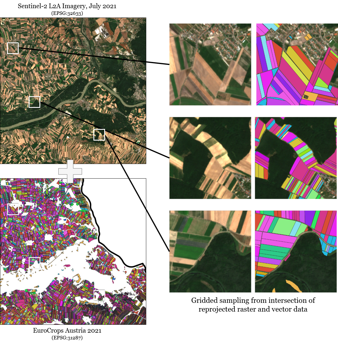
To make this more concrete, let us say that the raster images are from Sentinel-2 (Drusch et al., 2012) and the vector files are from EuroCrops (Schneider et al., 2023) (see Figure 2). The goal is to perform crop type mapping, with each pixel being assigned to one of 200 crop classes. This requires reprojection, rasterization, and chipping of each image and vector file into smaller image patches that can be passed through the model. For the model, we will use a simple U-Net (Ronneberger et al., 2015) architecture with a ResNet-50 (He et al., 2016) backbone.
Now, let us see how this task can be solved with various levels of abstraction using TorchGeo. TorchGeo is available on PyPI and Conda Forge, and can easily be installed using:
TorchGeo is designed with the same API as other PyTorch domain libraries. The below code should look familiar to anyone with experience using libraries like torchvision and PyTorch Lightning. The following examples demonstrate three different levels of abstraction, each with their own pros and cons.22 2 Maintained and well-tested notebooks for many of these application examples can be found at: https://torchgeo.rtfd.io/en/latest/tutorials/getting_started.html.
4.1 Pure PyTorch
For maximum control and customization, TorchGeo datasets, samplers, and pre-trained models can be used directly. While the data loader setup is a bit custom, the rest of the training and evaluation pipeline is identical to other PyTorch domain libraries.
First, we import everything we will later require.
Given a user-defined local directory or list of remote file paths, we next instantiate PyTorch Dataset objects for Sentinel-2 and EuroCrops data. Given a spatiotemporal slice, this dataset is responsible for loading the data at that time and location from disk. We then compute the spatiotemporal intersection of these datasets. All data is automatically reprojected to a shared CRS and rasterized on the fly.
Next, we overlay a grid over the dataset. Each grid cell is randomly assigned to a train, validation, or test split using an 80:10:10 split. Note that TorchGeo has other geospatial splitting strategies that may be more suitable for out-of-distribution evaluation.
Next, we instantiate PyTorch Sampler objects for each split. The sampler is responsible for telling the dataset where and when to load data from. Here, we use random sampling at training time to maximize the diversity of the training data and grid-based sampling at evaluation time to avoid overlap or missing locations.
All TorchGeo datasets and samplers are compatible with PyTorch’s built-in DataLoader class. Here, we set the batch size and tell the data loader where it is allowed to sample from.
We use Kornia for our preprocessing and data augmentation transforms. Preprocessing is required to ensure that all inputs are in the 0–1 range, regardless of whether the original imagery was in uint8 or uint12 format. Data augmentation is helpful to artificially inflate the size of the training dataset.
Next, we instantiate our model. TorchGeo comes with 120+ model weights pre-trained on SAR, RGB, MSI, and HSI remote sensing imagery. In this case, we use a model pre-trained on all 13 bands of Sentinel-2 imagery using self-supervised learning (Wang et al., 2023).
We next transfer our model to the GPU. Note that this step may look different for NVIDIA, AMD, and Apple Silicon GPUs.
For our loss function, we choose cross-entropy loss, which works well for multiclass classification and semantic segmentation tasks. For our optimizer, we choose stochastic gradient descent (SGD). Users can and should experiment with fancier optimizers here.
We define a train function containing the forward and backward pass of our model for a single epoch.
We define a similar evaluation function containing the forward pass of our model and compute the overall accuracy of a single epoch.
Finally, we combine everything and train and evaluate our model over 100 epochs. Validation accuracy can be used for early stopping and for hyperparameter tuning. Once an optimal set of hyperparameters is found, we report the final test accuracy.
4.2 PyTorch Lightning
While the above code has the most flexibility and can be easily customized to add preprocessing or data augmentation, it can be daunting for many users. Beginners are likely to make mistakes when computing accuracy metrics, while experts may require a lot of code duplication if they want to, for example, evaluate several model architectures on dozens of different datasets. To simplify the training and evaluation pipeline, TorchGeo offers PyTorch Lightning (Falcon & The PyTorch Lightning team, 2019) integration. PyTorch Lightning introduces two ideas: data modules, collections of train/val/test datasets and the transforms applied to them, and modules, reusable recipes for tasks like classification, regression, or semantic segmentation. TorchGeo provides built-in data modules for many datasets and modules for:
- •
Classification (binary, multiclass, multilabel)
- •
Regression (imagewise, pixelwise)
- •
Semantic Segmentation (binary, multiclass, multilabel)
- •
Change Detection (binary, multiclass, multilabel)
- •
Object Detection
- •
Instance Segmentation
- •
Self-Supervised Learning (BYOL (Grill et al., 2020), MoCo (He et al., 2020), SimCLR (Chen et al., 2020))
The following code can be easily extended to support TensorBoard logging (Lee, 2015), early stopping, and model checkpointing, and implements all of the steps from the previous section with significantly fewer lines of code.
4.3 Command Line
In the research community, easy experimentation and reproducibility are paramount. TorchGeo offers a command-line interface based on LightningCLI, with support for command-line, YAML, and JSON configuration. The following YAML file can be used to reproduce an experiment from a paper without writing a single line of code.
Once TorchGeo is installed, the user simply needs to run commands like fit or test to train and evaluate their model.
5 Best Practices and Open Issues
With so many successful or abandoned GeoML libraries over the years, there is a wealth of information on best practices to follow (and also what to avoid). Despite significant progress towards forming a consensus on code and data hosting repositories, there are still many open issues for future generations to tackle.
5.1 File Formats
One of the primary purposes of GeoML libraries is to load and preprocess data. Thus, choosing the right file format is critical to achieve efficient I/O and keep the GPU busy. While GeoML libraries themselves are often agnostic to file format and support a wide range of file types, users of GeoML libraries can drastically improve the speed of training and inference by choosing the right file type.
For uncurated raster and vector data layers, GeoTIFF and ESRI Shapefile have long been standard. In particular, so-called “cloud optimized GeoTIFFs” (COGs) support fast and efficient windowed reading, allowing tools like TorchGeo to load small image patches without reading the entire file from disk. Preprocessing, including manual reprojection, target aligned pixels (TAP), and compression, can all improve I/O performance (Stewart et al., 2024).
For curated ML-ready benchmark datasets, geospatial metadata is often unnecessary or absent. Typical file formats include PNG and JPEG, with newer file formats like Parquet and Zarr becoming more common for larger datasets. Language- or software-specific file formats like PyTorch’s .pth, NumPy’s .npy, or Python’s pickle should be avoided to ensure cross-language support.
Large-scale datasets commonly used for self-supervised learning and foundation model pretraining require their own careful consideration. Datasets such as SSL4EO (Wang et al., 2023; Stewart et al., 2023), SatlasPretrain (Bastani et al., 2023), and CopernicusPretrain (Wang et al., 2025) consist of anywhere from millions to billions of files, easily enough to overwhelm all but the largest compute clusters. Modern formats like WebDataset (Breuel, 2019) and LitData (Chaton & Lightning AI, 2023) offer support for sharding and streaming data, avoiding inode and storage limits.
5.2 Distribution
GitHub is the primary hosting platform for GeoML libraries, with every single library on the list being developed or mirrored on GitHub. While many geospatial software packages are still hosted on private servers like OSGeo and bug reports are filed through TRAC, GitHub has long been popular within the ML community. Having a single shared platform for everything from version control to continuous integration to bug reporting makes it easier for potential users to find your software and potential contributors to improve your software.
While GitHub can be used for release distribution, the vast majority of successful GeoML libraries are distributed through language-specific servers like PyPI (Python), CRAN (R), or Conda-Forge (Python/R). In fact, most of the abandoned GeoML libraries on our list either never had stable releases, or were only distributed through git clone or docker pull. In the Python ecosystem, pre-compiled binaries (bdists) such as wheels are critical for ease of installation, especially on Windows.
GeoML datasets and pre-trained model weights can be found on a variety of platforms, with personal Google Drive, OneDrive, and Baidu Drive being common. However, these platforms should be avoided for serious scientific advances, as it is too easy to accidentally delete the wrong file or directory. Instead, dedicated data hosting platforms like Zenodo or Hugging Face should be used instead. While AWS S3 buckets and Source Cooperative repositories are useful for extremely large datasets, they lack stable download URLs and checksumming capabilities required to ensure reproducibility.
5.3 Licensing
One of the most important considerations for developers and users of GeoML software is the license under which it is distributed. Often overlooked by researchers, the license allows the owner of the IP (copyright, trademark, and/or patent) to explicitly grant certain permissions, with certain limitations, subject to certain conditions. For example, the popular MIT license grants the user permission to redistribute and modify the software, including commercial and private use, limiting liability and warranty of the developer, under the condition that the user preserves the license and copyright notice. In this sense, licenses protect both the users and contributors.
There are two broad families of licenses: permissive and copyleft. Permissive licenses like MIT and Apache-2.0 are generally more relaxed, with the only condition that the license must be preserved. Copyleft licenses like the GNU Public License (GPL), on the other hand, impose strict constraints on users such that any code bundled with the software must be released under the same license. Copyleft licenses are generally incompatible with industry, limiting adoption by many communities. With the exception of SITS, ML4Floods, and GeoDeep, every single GeoML library under active development is released under a permissive license (see Table 2), reflecting the broader Python and ML communities. SITS, like R itself, is licensed under GPL, restricting its use primarily to academic settings.
While software licenses can technically be used for data and models, many of the clauses in these licenses are not applicable to data or models. Instead, the Creative Commons family of licenses is more common, including CC0 (public domain), CC-BY (Attribution), CC-BY-SA (Attribution-ShareAlike), and CC-BY-NC (Attribution-NonCommercial). Responsible AI Licenses (RAIL) are another family of licenses tailored specifically for the AI community, with subcategories for Data, Apps, Models, and Source code. However, it is worth noting that CC-BY-NC and OpenRAIL are not considered to be open source licenses, as they restrict certain usage.
The important thing for both code and data is to choose a license33 3 https://choosealicense.com/ and stick with it. In particular, datasets without licenses are unfortunately pervasive and challenging for GeoML libraries. While rarely enforced, it is technically illegal to even download let alone use or redistribute data without a license.
5.4 Continuous Integration
A good software library is not complete without continuous integration (CI), suites of checks and tests to ensure software quality that typically run on every commit, branch, pull request, and release. GitHub Actions is currently the dominant CI platform for free, public libraries, replacing Travis CI and CircleCI which dominated before its release.
CI can and should consist of a variety of different types of testing. The most obvious is unit testing, designed to ensure that individual functions and classes behave as they are designed to. Testing frameworks, including pytest for Python and testthat for R, handle the heavy lifting, allowing one to quickly add test cases (expected output given a certain input). Many libraries also run integration tests on release branches, ensuring that functions and classes can be integrated into a larger framework. Test coverage is particularly important as it ensures that the majority of the library is touched by unit tests. Test coverage can be reported by services including Codecov and Coveralls. Software libraries with less than 80% test coverage are generally not recommended for production use and should be considered unstable.
Even more important than unit testing is documentation. Tools like Sphinx can be used to build and test the documentation, and documentation hosting sites like ReadTheDocs provide CI support, allowing developers to see the documentation generated by each pull request. Sphinx can also automatically generate API documentation from function and class docstrings, allowing you to easily maintain high-quality documentation.
Dynamically typed languages like Python can also benefit from type hints. Tools like mypy, pytype, pyright, pyre, and ty can be used to enforce strict static typing, preventing a number of bugs caused by bad typing practices. Tools like Sphinx can even use these type hints when generating API documentation. Similarly, tools like flake8, isort, black, and ruff can be used to enforce style guides, resulting in well-formatted code. While these may not seem important for single-author projects, they become critical for maintaining projects with hundreds of contributors.
5.5 Open Issues
Testing and reproducibility (Heil et al., 2021) remain the biggest challenges faced by GeoML libraries at the moment. While many actively maintained GeoML libraries have over 90% test coverage (see Table 2), the majority fall far below, with some having no testing at all. A lack of tests puts these projects at risk of both bugs (unexpected or incorrect behavior) and regressions (when a fixed bug resurfaces later). In addition, tests can ensure software stability, warning developers of unintentional backwards-incompatible changes and allowing them to mitigate or document the change before making a release.
Test coverage itself is not the only important metric. Just because a line of code can be executed without raising an error does not mean it produces a desirable result. Machine learning is inherently stochastic, with non-determinism originating from the data (cross validation split, data augmentation, random shuffling), the model (initial weights, dropout layers), and the optimization process (SGD, momentum, learning rate scheduler). While setting a random seed can alleviate some of these sources of non-determinism, reproducibility is not guaranteed across software versions, platforms, and accelerators (CPU, GPU, TPU). This makes testing challenging for developers and perfect reproducibility practically impossible for users.
As datasets and models continue to grow in size, computational performance becomes increasingly important. Maximizing I/O and data transfer speeds, especially for parallel filesystems and on distributed compute, remains an important challenge. Libraries like Kornia (Riba et al., 2020) address some of these challenges by implementing data augmentations directly in PyTorch or Rust, providing significant speedups over pure Python implementations. It may be possible to achieve similar speedups for reprojection and resampling, often the biggest bottlenecks for geospatial data processing, by implementing these operations in PyTorch or CUDA and performing them on the GPU.
6 Future Implications
With increased interest in and funding for geospatial intelligence by industry, the future of GeoML libraries looks promising. Below, we list our own predictions for what the next five years will look like.
6.1 Foundation Models to Embeddings
Foundation models (Bommasani et al., 2021) — large, task-agnostic deep learning models pretrained on massive amounts of data — have dominated the last few years of research (see the self-supervised learning chapter of this book). We expect this dominance to continue, especially in the geospatial domain where scientists so often deal with limited labeled data. While most current research focuses on EO foundation models for SAR and MSI satellite imagery, we expect foundation models to expand to a greater number of modalities, including HSI, UAV, and LiDAR data.
We also anticipate the development of unified foundation models for the land surface, ocean, and atmosphere (Zhu et al., 2024). This is especially important in the area of weather and climate modeling, where these processes are all interconnected and cannot be individually modeled. Application domains like air pollution and nowcasting provide new challenges for GeoML libraries, forcing the incorporation of real-time point data in unstructured graphs instead of curated raster data.
The recent release of a number of high-profile foundation model embeddings, including Major TOM (Czerkawski et al., 2024) and AlphaEarth Foundations (Brown et al., 2025), raises the question: are GeoML libraries still necessary? Deep learning can be very computationally demanding and requires technical expertise that many users lack, while pre-computed global embeddings allow users to run simple linear probing layers or -NN models directly on foundation model outputs. However, GeoML libraries are still necessary to generate new embeddings, and foundation model fine-tuning still offers higher performance. Conversely, embeddings have opened the door for a new type of GeoML library, like GeoTessera, which ease the use of large-scale embeddings.
6.2 Growing Focus on Reuse and Ease of Use
The majority of the history of GeoML libraries has seen a “reinvention of the wheel”, with new libraries introducing clever ideas and solutions for common challenges without reusing older libraries. This is especially true for pipeline-based libraries like Raster Vision and eo-learn, which are easy to use but difficult to build on top of. The introduction of component-based libraries like TorchGeo has changed this, with libraries like GEO-Bench, TerraTorch, and GeoAI supplementing instead of replacing TorchGeo.
Foundation models and embeddings have shown us that ease of use is often more important than accuracy. We expect further abstractions on top of component-based libraries providing low-code or no-code solutions for GIS domain experts. A handful of machine learning plugins already exist for ArcGIS and QGIS, but lack the power and features of existing GeoML libraries. Vision–language foundation models like DOFA-CLIP (Xiong et al., 2025) present an interesting opportunity for zero-shot learning, in which the user can ask the model to perform a task using natural language.
6.3 Independent Governance and Software Foundations
However, successful software is often made by multiple people working together on behalf of a company or research institution. This incubation process provides the necessary funding and advertising needed for the project to take off. After gaining popularity, successful software can quickly outgrow the organization that created it. Once this happens, independent governance is required to allow the project to continue to grow. Examples of this include PyTorch (developed by Meta) and TensorFlow/Keras/JAX (developed by Google), which are now governed by independent teams of maintainers.
Several GeoML libraries have graduated beyond this incubation status and achieved open and independent governance. OTB gained independence from CNES and announced its new open governance model in March of 2015. PySAL has always been independent and adopted a formal governance structure in February of 2019. TorchGeo gained independence from Microsoft in August of 2025 and now holds monthly Technical Steering Committee meetings open to the public. All three of these libraries have cultivated successful open source ecosystems, with further GeoML libraries extending their capabilities: OTB (OTBTF), PySAL (spopt), and TorchGeo (GEO-Bench, GeoAI, TerraTorch).
An interesting question is what role software foundations should play in this incubation process. Many geospatial and ML software foundations exist, including the Open Source Geospatial Foundation (OSGeo), the PyTorch Foundation, the Linux Foundation AI & Data, and the AI Alliance. OTB and TorchGeo already belong to OSGeo, while TerraTorch recently joined the AI Alliance. These foundations provide advertising, financial support, and legal support for a variety of software projects, promoting collaboration between member projects. These software foundations could provide a neutral home for many such GeoML libraries.
Acknowledgments
The authors would like to thank the contributors to and maintainers of all GeoML software for their tireless efforts in building much-needed software infrastructure for this domain. In particular, we would like to thank Nicolas Audebert (author of DeepNetsForEO and DeepHyperX) and Gilberto Camara (author of SITS) for sharing their knowledge about the early history of GeoML software. We would also like to thank Robin Cole and Eduardo Lacerda for maintaining listings of all major GeoML libraries throughout recent years. The work was supported in part by the National Science Foundation (NSF) through awards IIS 21-31335, OAC 21-30835, DBI 20-21898, as well as a C3.ai research award.
References
- Abadi et al. (2016) Martín Abadi, Paul Barham, Jianmin Chen, Zhifeng Chen, Andy Davis, Jeffrey Dean, Matthieu Devin, Sanjay Ghemawat, Geoffrey Irving and Michael Isard “TensorFlow: A system for large-scale machine learning” In 12th USENIX Symposium on Operating Systems Design and Implementation (OSDI 16), 2016, pp. 265–283
- Aleksandrov (2018) Matej Aleksandrov “eo-learn: Earth observation processing framework for machine learning in Python”, https://github.com/sentinel-hub/eo-learn, 2018
- Alexandrov et al. (2020) Alexander Alexandrov, Konstantinos Benidis, Michael Bohlke-Schneider, Valentin Flunkert, Jan Gasthaus, Tim Januschowski, Danielle Maddix, Syama Rangapuram, David Salinas and Jasper Schulz “GluonTS: Probabilistic and neural time series modeling in Python” In Journal of Machine Learning Research 21.116, 2020, pp. 1–6
- Aszkowski et al. (2023) Przemysław Aszkowski, Bartosz Ptak, Marek Kraft, Dominik Pieczyński and Paweł Drapikowski “Deepness: Deep neural remote sensing plugin for QGIS” In SoftwareX 23, 2023, pp. 101495 DOI: https://doi.org/10.1016/j.softx.2023.101495
- Audebert et al. (2019) N. Audebert, B. Le Saux and S. Lefèvre “Deep Learning for Classification of Hyperspectral Data: A Comparative Review” In IEEE Geoscience and Remote Sensing Magazine 7.2, 2019, pp. 159–173 DOI: 10.1109/MGRS.2019.2912563
- Audebert et al. (2017) Nicolas Audebert, Bertrand Saux and Sébastien Lefèvre “Beyond RGB: Very high resolution urban remote sensing with multimodal deep networks” In ISPRS Journal of Photogrammetry and Remote Sensing, 2017 DOI: https://doi.org/10.1016/j.isprsjprs.2017.11.011
- Azavea/Element 84 & Cheetham (2017) Azavea/Element 84 and Robert Cheetham “Raster Vision: An open source library and framework for deep learning on satellite and aerial imagery (2017-2023).”, https://github.com/azavea/raster-vision, 2017
- Bastani et al. (2023) Favyen Bastani, Piper Wolters, Ritwik Gupta, Joe Ferdinando and Aniruddha Kembhavi “SatlasPretrain: A large-scale dataset for remote sensing image understanding” In Proceedings of the IEEE/CVF International Conference on Computer Vision, 2023, pp. 16772–16782
- Bhadra (2023) Sourav Bhadra “Raster4ML: A geospatial raster processing library for machine learning”, https://github.com/souravbhadra/raster4ml, 2023
- Boggs (2001) Thomas Boggs “Spectral Python (SPy): Python module for hyperspectral image processing”, https://github.com/spectralpython/spectral, 2001
- Bommasani et al. (2021) Rishi Bommasani, Drew Hudson, Ehsan Adeli, Russ Altman, Simran Arora, Sydney von Arx, Michael Bernstein, Jeannette Bohg, Antoine Bosselut and Emma Brunskill “On the opportunities and risks of foundation models” In arXiv preprint arXiv:2108.07258, 2021
- Bradski & Kaehler (2000) Gary Bradski and Adrian Kaehler “OpenCV” In Dr. Dobb’s Journal of Software Tools 3.2, 2000
- Breuel (2019) Thomas Breuel “WebDataset: A high-performance Python-based I/O system for large (and small) deep learning problems, with strong support for PyTorch”, https://github.com/webdataset/webdataset, 2019
- Brockman et al. (2016) Greg Brockman, Vicki Cheung, Ludwig Pettersson, Jonas Schneider, John Schulman, Jie Tang and Wojciech Zaremba “OpenAI Gym” In arXiv preprint arXiv:1606.01540, 2016
- Brown et al. (2025) Christopher Brown, Michal Kazmierski, Valerie Pasquarella, William Rucklidge, Masha Samsikova, Chenhui Zhang, Evan Shelhamer, Estefania Lahera, Olivia Wiles and Simon Ilyushchenko “AlphaEarth Foundations: An embedding field model for accurate and efficient global mapping from sparse label data” In arXiv preprint arXiv:2507.22291, 2025
- Camara et al. (2024) Gilberto Camara, Rolf Simoes, Felipe Souza, Felipe Carlos, Charlotte Pelletier, Pedro. Andrade, Karine Ferreira and Gilberto Queiroz “SITS - Satellite Image Time Series Analysis on Earth Observation Data Cubes” National Institute for Space Research (INPE), Brazil, 2024
- Chang & Lin (2011) Chih-Chung Chang and Chih-Jen Lin “LIBSVM: A library for support vector machines” In ACM transactions on intelligent systems and technology (TIST) 2.3 Acm New York, NY, USA, 2011, pp. 1–27
- Chaton & Lightning AI (2023) Thomas Chaton and Lightning AI “LitData: Transform datasets at scale. Optimize datasets for fast AI model training”, https://github.com/Lightning-AI/litdata, 2023
- Chen & Shi (2020) Hao Chen and Zhenwei Shi “A spatial-temporal attention-based method and a new dataset for remote sensing image change detection” In Remote Sensing 12.10 MDPI, 2020, pp. 1662
- Chen et al. (2020) Ting Chen, Simon Kornblith, Mohammad Norouzi and Geoffrey Hinton “A simple framework for contrastive learning of visual representations” In International Conference on Machine Learning, 2020, pp. 1597–1607 PmLR
- Chowdhury & Sarwat (2022) Kanchan Chowdhury and Mohamed Sarwat “GeoTorch: A Spatiotemporal Deep Learning Framework” In SIGSPATIAL ’22 Seattle, Washington: Association for Computing Machinery, 2022 DOI: 10.1145/3557915.3561036
- Collette (2008) Andrew Collette “HDF5 for Python – The h5py package is a Pythonic interface to the HDF5 binary data format”, https://github.com/h5py/h5py, 2008
- Coltin (2019) Brian Coltin “DELTA: Deep Learning for Satellite Imagery”, https://github.com/nasa/delta, 2019
- Corley (2021) Isaac Corley “torchrs: PyTorch implementation of popular datasets and models in remote sensing”, https://github.com/isaaccorley/torchrs, 2021
- Cresson (2018) Rémi Cresson “A framework for remote sensing images processing using deep learning techniques” In IEEE Geoscience and Remote Sensing Letters 16.1 IEEE, 2018, pp. 25–29
- Czerkawski et al. (2024) Mikolaj Czerkawski, Marcin Kluczek and JÄ Bojanowski “Global and dense embeddings of Earth: Major TOM floating in the latent space” In arXiv preprint arXiv:2412.05600, 2024
- Damien (2016) Aymeric Damien “TFLearn: Deep learning library featuring a higher-level API for TensorFlow”, https://github.com/tflearn/tflearn, 2016
- Deng et al. (2009) Jia Deng, Wei Dong, Richard Socher, Li-Jia Li, Kai Li and Li Fei-Fei “ImageNet: A large-scale hierarchical image database” In 2009 IEEE Conference on Computer Vision and Pattern Recognition, 2009, pp. 248–255 IEEE
- Dimitrovski et al. (2023) Ivica Dimitrovski, Ivan Kitanovski, Dragi Kocev and Nikola Simidjievski “Current Trends in Deep Learning for Earth Observation: An Open-source Benchmark Arena for Image Classification” In ISPRS Journal of Photogrammetry and Remote Sensing 197, 2023, pp. 18–35
- Dimitrovski et al. (2023a) Ivica Dimitrovski, Ivan Kitanovski, Panče Panov, Ana Kostovska, Nikola Simidjievski and Dragi Kocev “AiTLAS: Artificial Intelligence Toolbox for Earth Observation” In Remote Sensing 15.9, 2023 DOI: 10.3390/rs15092343
- Drusch et al. (2012) Matthias Drusch, Ugo Del, Séverine Carlier, Olivier Colin, Viviana Fernandez, Ferran Gascon, Bernhard Hoersch, Cécile Isola, P. Laberinti, Philippe Martimort, Alain Meygret and Federica Spoto “Sentinel-2: ESA’s Optical High-Resolution Mission for GMES Operational Services” In Remote Sensing of Environment 120, 2012, pp. 25–36 DOI: 10.1016/j.rse.2011.11.026
- Falcon & The PyTorch Lightning team (2019) William Falcon and The PyTorch Lightning team “PyTorch Lightning”, https://github.com/Lightning-AI/lightning, 2019
- Feng et al. (2022) Xin Feng, Germano Barcelos, James. Gaboardi, Elijah Knaap, Ran Wei, Levi. Wolf, Qunshan Zhao and Sergio. Rey “spopt: a Python package for solving spatial optimization problems in PySAL” In Journal of Open Source Software 7.74 The Open Journal, 2022, pp. 3330 DOI: 10.21105/joss.03330
- Feng et al. (2025) Zhengpeng Feng, Clement Atzberger, Sadiq Jaffer, Jovana Knezevic, Silja Sormunen, Robin Young, Madeline Lisaius, Markus Immitzer, David. Coomes, Anil Madhavapeddy, Andrew Blake and Srinivasan Keshav “TESSERA: Temporal Embeddings of Surface Spectra for Earth Representation and Analysis”, 2025 arXiv: https://arxiv.org/abs/2506.20380
- Fuller et al. (2023) Anthony Fuller, Koreen Millard and James Green “CROMA: Remote sensing representations with contrastive radar-optical masked autoencoders” In Advances in Neural Information Processing Systems 36, 2023, pp. 5506–5538
- Gaydon (2022) Charles Gaydon “Myria3D: Deep Learning for the Semantic Segmentation of Aerial Lidar Point Clouds”, https://github.com/IGNF/myria3d, 2022
- GDAL/OGR contributors (2022) GDAL/OGR contributors “GDAL/OGR Geospatial Data Abstraction software Library”, 2022 Open Source Geospatial Foundation DOI: 10.5281/zenodo.5884351
- Gillies (2013) Sean Gillies “Rasterio: geospatial raster I/O for Python programmers”, https://github.com/rasterio/rasterio, 2013
- Gillies et al. (2024) Sean Gillies, René Buffat, Joshua Arnott, Mike. Taves, Kevin Wurster, Alan. Snow, Micah Cochran, Elliott Sales and Matthew Perry “Fiona”, 2024 URL: https://github.com/Toblerity/Fiona
- Gohlke (2018) Christoph Gohlke “tifffile: read and write TIFF files”, https://github.com/cgohlke/tifffile, 2018
- Gomes et al. (2025) Carlos Gomes, Benedikt Blumenstiel, Joao Almeida, Pedro de Oliveira, Paolo Fraccaro, Francesc Escofet, Daniela Szwarcman, Naomi Simumba, Romeo Kienzler and Bianca Zadrozny “TerraTorch: The Geospatial Foundation Models Toolkit” In arXiv preprint arXiv:2503.20563, 2025
- Gramacki et al. (2023) Piotr Gramacki, Kacper Leśniara, Kamil Raczycki, Szymon Woźniak, Marcin Przymus and Piotr Szymański “SRAI: Towards Standardization of Geospatial AI” In Proceedings of the 6th ACM SIGSPATIAL International Workshop on AI for Geographic Knowledge Discovery Association for Computing Machinery, 2023 URL: https://dl.acm.org/doi/10.1145/3615886.3627740
- Grill et al. (2020) Jean-Bastien Grill, Florian Strub, Florent Altché, Corentin Tallec, Pierre Richemond, Elena Buchatskaya, Carl Doersch, Bernardo Avila, Zhaohan Guo and Mohammad Gheshlaghi “Bootstrap your own latent-a new approach to self-supervised learning” In Advances in Neural Information Processing Systems 33, 2020, pp. 21271–21284
- Grizonnet et al. (2017) Manuel Grizonnet, Julien Michel, Victor Poughon, Jordi Inglada, Mickaël Savinaud and Rémi Cresson “Orfeo ToolBox: open source processing of remote sensing images” In Open Geospatial Data, Software and Standards 2.1 Springer, 2017, pp. 15
- Harada (2023) Nate Harada “Moonshine: Pretrained remote sensing models for the rest of us”, https://github.com/moonshinelabs-ai/moonshine, 2023
- Harris et al. (2020) Charles. Harris, K. Millman, Stéfan van Walt, Ralf Gommers, Pauli Virtanen, David Cournapeau, Eric Wieser, Julian Taylor, Sebastian Berg, Nathaniel. Smith, Robert Kern, Matti Picus, Stephan Hoyer, Marten. van Kerkwijk, Matthew Brett, Allan Haldane, Jaime Fernándezío, Mark Wiebe, Pearu Peterson, Pierre Gérard-Marchant, Kevin Sheppard, Tyler Reddy, Warren Weckesser, Hameer Abbasi, Christoph Gohlke and Travis. Oliphant “Array programming with NumPy” In Nature 585, 2020, pp. 357–362 DOI: 10.1038/s41586-020-2649-2
- He et al. (2020) Kaiming He, Haoqi Fan, Yuxin Wu, Saining Xie and Ross Girshick “Momentum contrast for unsupervised visual representation learning” In Proceedings of the IEEE/CVF Conference on Computer Vision and Pattern Recognition, 2020, pp. 9729–9738
- He et al. (2016) Kaiming He, Xiangyu Zhang, Shaoqing Ren and Jian Sun “Deep residual learning for image recognition” In Proceedings of the IEEE Conference on Computer Vision and Pattern Recognition, 2016, pp. 770–778
- Heil et al. (2021) Benjamin Heil, Michael Hoffman, Florian Markowetz, Su-In Lee, Casey Greene and Stephanie Hicks “Reproducibility standards for machine learning in the life sciences” In Nature Methods 18.10 Nature Publishing Group US New York, 2021, pp. 1132–1135
- Hijmans et al. (2018) Robert. Hijmans, Márcia Barbosa, Roger Bivand, Andrew Brown, Michael Chirico, Emanuele Cordano, Krzysztof Dyba, Edzer Pebesma, Barry Rowlingson and Michael. Sumner “terra: R package for spatial data handling”, 2018 DOI: 10.32614/CRAN.package.terra
- Hofmann & Kowshik (2018) Daniel. Hofmann and Bhargav Kowshik “RoboSat: Generic ecosystem for feature extraction from aerial and satellite imagery”, https://github.com/mapbox/robosat, 2018
- Hoyer & Joseph (2017) Stephan Hoyer and Hamman Joseph “xarray: N-D labeled Arrays and Datasets in Python” In Journal of Open Research Software 5.1, 2017 DOI: 10.5334/jors.148
- Jia et al. (2014) Yangqing Jia, Evan Shelhamer, Jeff Donahue, Sergey Karayev, Jonathan Long, Ross Girshick, Sergio Guadarrama and Trevor Darrell “Caffe: Convolutional architecture for fast feature embedding” In Proceedings of the 22nd ACM International Conference on Multimedia, 2014, pp. 675–678
- Johnson (2016) Andrew. Johnson “DeepOSM: Train a deep learning net with OpenStreetMap features and satellite imagery”, https://github.com/trailbehind/DeepOSM, 2016
- Jordahl (2013) Kelsey Jordahl “GeoPandas: Python tools for geographic data”, https://github.com/geopandas/geopandas, 2013
- Karra et al. (2021) Krishna Karra, Caitlin Kontgis, Zoe Statman-Weil, Joseph Mazzariello, Mark Mathis and Steven Brumby “Global land use/land cover with Sentinel 2 and deep learning” In 2021 IEEE International Geoscience and Remote Sensing Symposium IGARSS Brussels, Belgium: IEEE, 2021, pp. 4704–4707
- Kellenberger et al. (2020) Benjamin Kellenberger, Devis Tuia and Dan Morris “AIDE: Accelerating image-based ecological surveys with interactive machine learning” In Methods in Ecology and Evolution 11.12 Wiley Online Library, 2020, pp. 1716–1727
- Kerner et al. (2025) Hannah Kerner, Snehal Chaudhari, Aninda Ghosh, Caleb Robinson, Adeel Ahmad, Eddie Choi, Nathan Jacobs, Chris Holmes, Matthias Mohr and Rahul Dodhia “Fields of the world: A machine learning benchmark dataset for global agricultural field boundary segmentation” In Proceedings of the AAAI Conference on Artificial Intelligence 39, 2025, pp. 28151–28159
- Kirillov et al. (2023) Alexander Kirillov, Eric Mintun, Nikhila Ravi, Hanzi Mao, Chloe Rolland, Laura Gustafson, Tete Xiao, Spencer Whitehead, Alexander Berg and Wan-Yen Lo “Segment anything” In Proceedings of the IEEE/CVF International Conference on Computer Vision, 2023, pp. 4015–4026
- Krause (2009) Oswin Krause “The Shark machine learning library”, https://github.com/Shark-ML/Shark, 2009
- Krizhevsky & Hinton (2009) Alex Krizhevsky and Geoffrey Hinton “Learning multiple layers of features from tiny images”, 2009
- Lacoste et al. (2023) Alexandre Lacoste, Nils Lehmann, Pau Rodriguez, Evan Sherwin, Hannah Kerner, Björn Lütjens, Jeremy Irvin, David Dao, Hamed Alemohammad and Alexandre Drouin “GEO-Bench: Toward foundation models for Earth monitoring” In Advances in Neural Information Processing Systems 36, 2023, pp. 51080–51093
- Lee (2015) Stephan Lee “TensorBoard: TensorFlow’s Visualization Toolkit”, https://github.com/tensorflow/tensorboard, 2015
- Ma et al. (2019) Yanjun Ma, Dianhai Yu, Tian Wu and Haifeng Wang “PaddlePaddle: An open-source deep learning platform from industrial practice” In Frontiers of Data and Computing 1.1, 2019, pp. 105–115
- Marcel & Rodriguez (2010) Sébastien Marcel and Yann Rodriguez “Torchvision the machine-vision package of torch” In Proceedings of the 18th ACM International Conference on Multimedia, 2010, pp. 1485–1488
- Mateo-Garcia et al. (2021) Gonzalo Mateo-Garcia, Joshua Veitch-Michaelis, Lewis Smith, Silviu Oprea, Guy Schumann, Yarin Gal, Atılımüneş Baydin and Dietmar Backes “Towards global flood mapping onboard low cost satellites with machine learning” In Scientific Reports 11.1, 2021, pp. 7249 DOI: 10.1038/s41598-021-86650-z
- Maxwell et al. (2024) Aaron Maxwell, Sarah Farhadpour, Srinjoy Das and Yalin Yang “geodl: An R package for geospatial deep learning semantic segmentation using torch and terra” In PloS one 19.12 Public Library of Science San Francisco, CA USA, 2024, pp. e0315127
- Miles (2015) Alistair Miles “Zarr: An implementation of chunked, compressed, N-dimensional arrays for Python”, https://github.com/zarr-developers/zarr-python, 2015
- Moliński (2022) Szymon Moliński “Pyinterpolate: Spatial interpolation in Python for point measurements and aggregated datasets” In Journal of Open Source Software 7.70, 2022, pp. 2869
- Mulla (2013) David. Mulla “Twenty five years of remote sensing in precision agriculture: Key advances and remaining knowledge gaps” Special Issue: Sensing Technologies for Sustainable Agriculture In Biosystems Engineering 114.4, 2013, pp. 358–371 DOI: 10.1016/j.biosystemseng.2012.08.009
- OpenStreetMap contributors (2017) OpenStreetMap contributors “OpenStreetMap”, https://www.openstreetmap.org, 2017
- PaddlePaddle Authors (2022) PaddlePaddle Authors “PaddleRS, Awesome Remote Sensing Toolkit based on PaddlePaddle”, https://github.com/PaddlePaddle/PaddleRS, 2022
- Paszke et al. (2019) Adam Paszke, Sam Gross, Francisco Massa, Adam Lerer, James Bradbury, Gregory Chanan, Trevor Killeen, Zeming Lin, Natalia Gimelshein, Luca Antiga, Alban Desmaison, Andreas Kopf, Edward Yang, Zachary DeVito, Martin Raison, Alykhan Tejani, Sasank Chilamkurthy, Benoit Steiner, Lu Fang, Junjie Bai and Soumith Chintala “PyTorch: An Imperative Style, High-Performance Deep Learning Library” In Advances in Neural Information Processing Systems 32 Curran Associates, Inc., 2019 URL: https://proceedings.neurips.cc/paper_files/paper/2019/file/bdbca288fee7f92f2bfa9f7012727740-Paper.pdf
- Pebesma (2018) Edzer Pebesma “Simple Features for R: Standardized Support for Spatial Vector Data” In The R Journal 10.1, 2018, pp. 439–446 DOI: 10.32614/RJ-2018-009
- Pedregosa et al. (2011) Fabian Pedregosa, Gaël Varoquaux, Alexandre Gramfort, Vincent Michel, Bertrand Thirion, Olivier Grisel, Mathieu Blondel, Peter Prettenhofer, Ron Weiss and Vincent Dubourg “Scikit-learn: Machine learning in Python” In Journal of Machine Learning Research 12 JMLR.org, 2011, pp. 2825–2830
- Reed et al. (2023) Colorado Reed, Ritwik Gupta, Shufan Li, Sarah Brockman, Christopher Funk, Brian Clipp, Kurt Keutzer, Salvatore Candido, Matt Uyttendaele and Trevor Darrell “Scale-MAE: A scale-aware masked autoencoder for multiscale geospatial representation learning” In Proceedings of the IEEE/CVF International Conference on Computer Vision, 2023, pp. 4088–4099
- Riba et al. (2020) E. Riba, D. Mishkin, D. Ponsa, E. Rublee and G. Bradski “Kornia: an Open Source Differentiable Computer Vision Library for PyTorch” In Winter Conference on Applications of Computer Vision, 2020 URL: https://arxiv.org/pdf/1910.02190.pdf
- Robinson et al. (2019) Caleb Robinson, Le Hou, Kolya Malkin, Rachel Soobitsky, Jacob Czawlytko, Bistra Dilkina and Nebojsa Jojic “Large scale high-resolution land cover mapping with multi-resolution data” In Proceedings of the IEEE/CVF Conference on Computer Vision and Pattern Recognition, 2019, pp. 12726–12735
- Rolf et al. (2024) Esther Rolf, Konstantin Klemmer, Caleb Robinson and Hannah Kerner “Position: mission critical–satellite data is a distinct modality in machine learning” In Forty-first International Conference on Machine Learning, 2024
- Rolnick et al. (2022) David Rolnick, Priya Donti, Lynn Kaack, Kelly Kochanski, Alexandre Lacoste, Kris Sankaran, Andrew Ross, Nikola Milojevic-Dupont, Natasha Jaques and Anna Waldman-Brown “Tackling climate change with machine learning” In ACM Computing Surveys (CSUR) 55.2 ACM New York, NY, 2022, pp. 1–96
- Ronneberger et al. (2015) Olaf Ronneberger, Philipp Fischer and Thomas Brox “U-Net: Convolutional networks for biomedical image segmentation” In Medical Image Computing and Computer-Assisted Intervention–MICCAI 2015, 2015, pp. 234–241 Springer
- Santara et al. (2016) Anirban Santara, Ankit Singh, Pranoot Hatwar, Kaustubh Mani and Pabitra Mitra “Hyperspectral: Deep Learning for Land-cover Classification in Hyperspectral Images”, https://github.com/KGPML/Hyperspectral, 2016
- Schneider et al. (2023) Maja Schneider, Tobias Schelte, Felix Schmitz and Marco Körner “EuroCrops: The largest harmonized open crop dataset across the European Union” In Scientific Data 10.1 Nature Publishing Group UK London, 2023, pp. 612
- Simoes et al. (2021) Rolf Simoes, Gilberto Camara, Gilberto Queiroz, Felipe Souza, Pedro Andrade, Lorena Santos, Alexandre Carvalho and Karine Ferreira “Satellite image time series analysis for big Earth observation data” In Remote Sensing 13.13 MDPI, 2021, pp. 2428
- Snow (2019) Alan. Snow “rioxarray: geospatial xarray extension powered by rasterio”, https://github.com/corteva/rioxarray, 2019
- Stewart et al. (2023) Adam Stewart, Nils Lehmann, Isaac Corley, Yi Wang, Yi-Chia Chang, Nassim Ait, Shradha Sehgal, Caleb Robinson and Arindam Banerjee “SSL4EO-L: Datasets and foundation models for Landsat imagery” In Advances in Neural Information Processing Systems 36, 2023, pp. 59787–59807
- Stewart et al. (2024) Adam. Stewart, Caleb Robinson, Isaac. Corley, Anthony Ortiz, Juan. Lavista and Arindam Banerjee “TorchGeo: Deep Learning With Geospatial Data” In ACM Transactions on Spatial Algorithms and Systems, 2024 DOI: 10.1145/3707459
- Tarazona et al. (2024) Yonatan Tarazona, Fernando Benitez-Paez, Jakub Nowosad, Fabian Drenkhan and Martín Timaná “scikit-eo: A Python package for Remote Sensing Data Analysis” In Journal of Open Source Software 9.99, 2024, pp. 6692
- Toffanin (2025) Piero Toffanin “GeoDeep: Free and open source library for AI object detection and semantic segmentation in geospatial rasters”, https://github.com/uav4geo/GeoDeep, 2025
- Van (2013) Cees Van “Remote sensing and GIS for natural hazards assessment and disaster risk management” In Treatise on Geomorphology 3 Academic Press San Diego, CA, 2013, pp. 259–298
- Waldmann et al. (2025) Leonard Waldmann, Ando Shah, Yi Wang, Nils Lehmann, Adam Stewart, Zhitong Xiong, Xiao Zhu, Stefan Bauer and John Chuang “Panopticon: Advancing Any-Sensor Foundation Models for Earth Observation” In arXiv preprint arXiv:2503.10845, 2025
- Wang (2019) Shuai Wang “TorchSat: an open-source deep learning framework for satellite imagery analysis based on PyTorch”, https://github.com/sshuair/torchsat, 2019
- Wang et al. (2023) Yi Wang, Nassim Ait, Zhitong Xiong, Chenying Liu, Conrad Albrecht and Xiao Zhu “SSL4EO-S12: A large-scale multimodal, multitemporal dataset for self-supervised learning in Earth observation” In IEEE Geoscience and Remote Sensing Magazine 11.3 IEEE, 2023, pp. 98–106
- Wang et al. (2025) Yi Wang, Zhitong Xiong, Chenying Liu, Adam Stewart, Thomas Dujardin, Nikolaos Bountos, Angelos Zavras, Franziska Gerken, Ioannis Papoutsis and Laura Leal-Taixé “Towards a Unified Copernicus Foundation Model for Earth Vision” In arXiv preprint arXiv:2503.11849, 2025
- Weinstein et al. (2020) Ben Weinstein, Sergio Marconi, Mélaine Aubry-Kientz, Gregoire Vincent, Henry Senyondo and Ethan White “DeepForest: A Python package for RGB deep learning tree crown delineation” In Methods in Ecology and Evolution 11.12 Wiley Online Library, 2020, pp. 1743–1751
- Weir (2019) Nick Weir “Solaris: CosmiQ Works Geospatial Machine Learning Analysis Toolkit”, https://github.com/CosmiQ/solaris, 2019
- Wolf et al. (2019) Thomas Wolf, Lysandre Debut, Victor Sanh, Julien Chaumond, Clement Delangue, Anthony Moi, Pierric Cistac, Tim Rault, Rémi Louf and Morgan Funtowicz “HuggingFace’s transformers: State-of-the-art natural language processing” In arXiv preprint arXiv:1910.03771, 2019
- Wu (2023) Qiusheng Wu “GeoAI: Artificial Intelligence for Geospatial Data”, https://github.com/opengeos/geoai, 2023
- Wu & Osco (2023) Qiusheng Wu and Lucas Osco “samgeo: A Python package for segmenting geospatial data with the Segment Anything Model (SAM)” In Journal of Open Source Software 8.89, 2023, pp. 5663 DOI: 10.21105/joss.05663
- Wu et al. (2019) Yuxin Wu, Alexander Kirillov, Francisco Massa, Wan-Yen Lo and Ross Girshick “Detectron2”, https://github.com/facebookresearch/detectron2, 2019
- Xiong et al. (2025) Zhitong Xiong, Yi Wang, Weikang Yu, Adam Stewart, Jie Zhao, Nils Lehmann, Thomas Dujardin, Zhenghang Yuan, Pedram Ghamisi and Xiao Zhu “DOFA-CLIP: Multimodal Vision-Language Foundation Models for Earth Observation” In arXiv preprint arXiv:2503.06312, 2025
- Xiong et al. (2024) Zhitong Xiong, Yi Wang, Fahong Zhang, Adam Stewart, Joëlle Hanna, Damian Borth, Ioannis Papoutsis, Bertrand Saux, Gustau Camps-Valls and Xiao Zhu “Neural plasticity-inspired multimodal foundation model for Earth observation” In arXiv preprint arXiv:2403.15356, 2024
- Yang et al. (2022) Yao-Yuan Yang, Moto Hira, Zhaoheng Ni, Artyom Astafurov, Caroline Chen, Christian Puhrsch, David Pollack, Dmitriy Genzel, Donny Greenberg and Edward Yang “Torchaudio: Building blocks for audio and speech processing” In ICASSP 2022-2022 IEEE International Conference on Acoustics, Speech and Signal Processing (ICASSP), 2022, pp. 6982–6986 IEEE
- Yu (2015) Jia Yu “Apache Sedona: A cluster computing framework for processing large-scale geospatial data”, https://github.com/apache/sedona, 2015
- Zhu et al. (2024) Xiao Zhu, Zhitong Xiong, Yi Wang, Adam Stewart, Konrad Heidler, Yuanyuan Wang, Zhenghang Yuan, Thomas Dujardin, Qingsong Xu and Yilei Shi “On the foundations of Earth and climate foundation models” In arXiv preprint arXiv:2405.04285, 2024